


Fort of Saint Anthony
Coordinates
Geographical: 37ş7'18'' N, 7ş37'17'' W
Decimal (GPS): 37.121638,-7.621502
Fort of Saint Anthony
Also known as Forte do Rato (fort of the mouse) and Forte da Ilha das Lebres (fort of the island of the hares), Forte de Santo António was built in the second half of the 16th century, at the entrance of the river Gilăo, with the purpose of defending the port of Tavira.
In the context of the War of Restoration (after 1640), it was remodelled to complement Fort of Săo Joăo da Barra, which was founded in 1672.
Featured
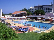 Hotel Eurotel Tavira
Quinta das Oliveiras, Tavira
Built in the grounds of the Quinta das Oliveiras farm, four kilometres (2.5 miles) away from the centre of Tavira, the Hotel Eurotel offers rooms equipped with air-conditioning, phone, minibar, bath, safe, satellite TV and balcony.
Best deals